Key Dates
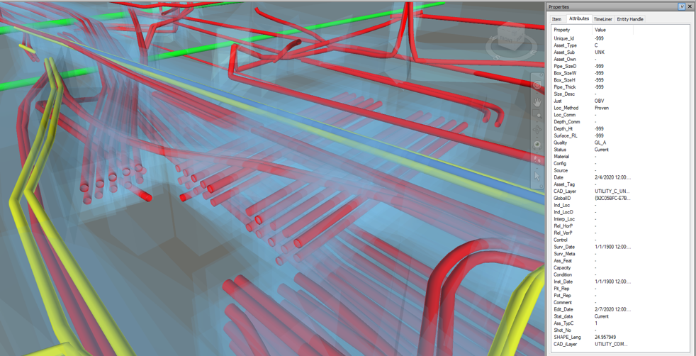
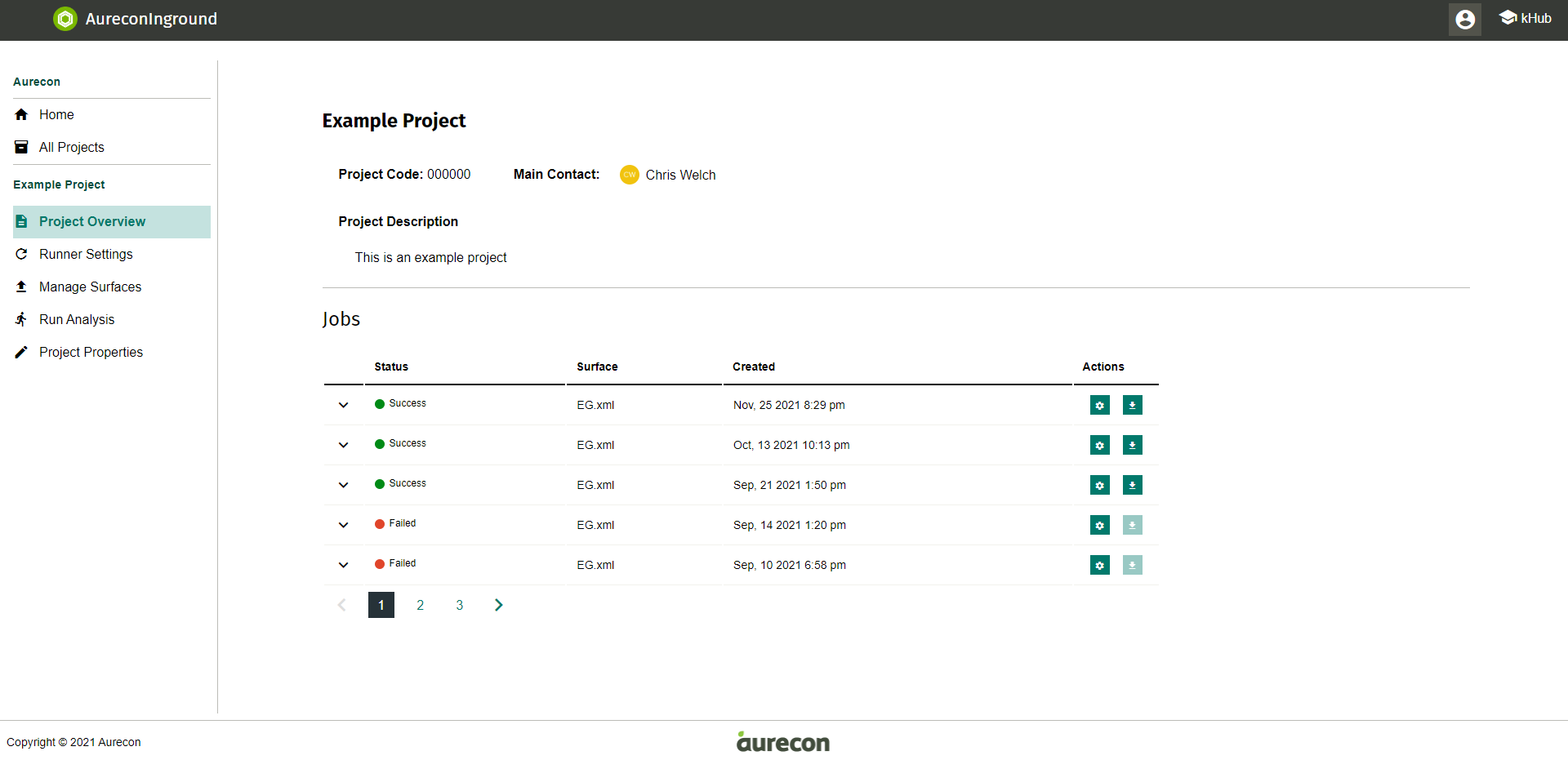
Image Credit : Aurecon

Project Overview
AureconInground is a web-based platform that facilitates the creation of data-rich 3D utility models from a wide range of data sources.
First, project teams gather and format existing utility data from a range of sources, including as-builts and surveys, into our standardised schema, and then store it in a geodatabase as the single source of truth.
Then, the geodatabase is processed by AureconInground, which automatically generates a fully attributed 3D utilities model. The resulting model includes tolerance zones around each utility, which vary in magnitude depending on the information’s accuracy.
Finally, these models are automatically converted into a range of fully attributed CAD file formats, ready to be passed on to the relevant project teams for reference and clash analysis.
AureconInground puts a standardised geodatabase at the heart of every project, and tightly links our model generation process with our data quality.
This strategy ensures that all project teams have access to the latest information, while clearly communicating through tolerance zones the potential for utilities to be in a physically different location to what the virtual model shows.
Organisation
Team
Jason Kroll, Qisi Zheng, Dan Fitzmaurice, Benn Cowen, Denise Mitnaul, Rebecca Strang, Tiaan Nel, Nick Williams, Dharman Gersch, Chris Welch
Project Brief
AureconInground is the continuation of a set of workflows and tools developed in Melbourne to support the delivery of inground utility models on major transport and land infrastructure projects. These workflows were well-received by the project teams and clients. Following this success, a brief was provided to Aurecon’s Computational Design (CoDe) team to productise and scale these tools.
The core request was to develop a web-based application that:
• Generates 3D models of existing utility models directly from a geospatial database following the AS5488 Classification of Sub Surface Utility Information,
• Allows for the systematic generation of good defaults where information is missing from a geospatial database, so that a valid 3D model can still be produced,
• Has no reliance on an external 3D modelling kernel or engine,
• Clearly communicates tolerances and assumptions in the assets it produces, both in attribution and in 3D model,
• Allows for a broad range of customisation based on client requirements,
• Allows for collaboration between users from various organisations, and
• Produces assets that work with file-based content engines, Computer Aided Design (CAD) software like Civil 3D and 12D, and the coordination software Navisworks.
The scope of delivery also extended to providing training, producing marketing collateral, ongoing support, and, in general, managing the rollout into the land and transport global capabilities.
Project Need
When large-scale infrastructure projects are designed, existing utility information is an incredibly important resource to collate. These inform engineers and designers about what assets are in the ground and where. Data can come from a range of sources like utility providers, councils, or surveys, which needs to be collated.
This data is frequently saved in PDF documents and is entirely in 2D, so viewing it in 3D requires making certain assumptions about it, such as how deep underground it is, and communicating that assumption.
The challenge is to ensure that design teams have the most up-to-date information at the right time, and that this information can be integrated directly into modern, 3D design and coordination software, and that any uncertainty in the model is also clearly communicated.
There is also a best practice requirement for sharing this data; rather than sending new data out in an email or in a set of design files, projects should have a single source of truth, where if a change is needed or refinement is required, it should be made in the source, and then queried from that source.
The architecture, engineering, and construction (AEC) industry is also shifting from desktop-based tools to web-based tools, which opens opportunities for secure, automated processes and queries of project data. We need to be open to both a wide range of vendors and formats, as well as enabling future best practice.
User Experience
AureconInground reduces risk by clearly communicating project tolerances, massively reducing model generation time, and encouraging best information management practice on large projects.
Users can create projects, add collaborators, and populate those projects with specific default settings for conversion. The user interface closely matches other Aurecon applications in layout, creating a consistent brand experience across our product line
.
Once a project is set up, an entire utilities model can be created in less than 30 seconds, ensuring that even entry-level staff can generate models once they are configured. Project history is fully auditable, with every change and setting change queryable by project stakeholders. To ensure the tool is future proofed for further automation of larger processes, all these tools are further accessible via API.
AureconInground enforces good practice by specifically working with geospatial databases, taking categorised asset information matching AS5488 and then automatically modelling and attributing these assets and their associated tolerance zones. This ensures that information related to the teams' best understanding of a project is baked into the produced asset, minimising the risk of information loss downstream.
To ensure the tool was completely standalone, a geometry kernel was developed to perform the intensive processing. This means that AureconInground can exist in any server configuration without relying on expensive, clunky CAD packages. It also means that end users do not need any CAD experience or access to CAD tools to produce a fully attributed 3D model in DXF, LandXML, or 12DXML.
Project Marketing
The core focus of the marketing push for AureconInground has been internal, building an understanding of the tool before it is deployed to all of Aurecon’s transport and land infrastructure projects. As such, the marketing and rollout of AureconInground was undertaken as a full business transformation exercise.
A carefully targeted training and rollout process was undertaken, collaborating with digital, survey, and geospatial experts from across the global business, market, and project leaders, to ensure that at any point in the delivery cycle, there would be an ‘Inground Champion’ who could help support getting the tool on projects.
Branding and marketing were produced following the same patterns and standards as other Aurecon tools to maintain a consistent look and feel across the suite of tools.
As well as training, collateral was produced to help support our champions delivering AureconInground on projects. This included case studies for successful projects, a pitch deck for market leaders, full technical documentation for detail-oriented staff, and costing strategies and calculation tools for project leaders.
Project Privacy
AureconInground has a complex security profile. Inground needs to be available to anyone at Aurecon and be protected by Single Sign On, while also available to select external staff on joint ventures or major Alliance projects, and, eventually, made available to external parties or other consultancies as a standalone application.
To meet these complex security needs, we chose to use a third party SAAS provider, with pass-through to our organisational identity service. This allows fine-grained control over external access to be administered through the SAAS portal, while also streamlining access assignment to internal users.
Inground connects to other Aurecon APIs so that in future, projects can be authorised to use Inground, and user permissions provided, through a separate UI that has a project-centric view of the world that allows project administrators a broader view of which tools are being used by which projects.
Digital - New Service or Application
This can be any new service or application from a start-up to an industry leader. It’s not just bells and whistles we're after but true innovation, exceeding expectations and filling a void that had previously been open.
More Details